Showing posts with label Canadian shield. Show all posts

Sunday, May 26, 2013

Gatineau Park - Huron Trail


Gatineau Park - Huron Trail


Length: 4.9 km (one way)
Time: 1-2 hours
Terrain: Moderate

The boots are knotted, the pack is full and the dog is excited... Today's hike is the Huron Trail located in Gatineau Park. Parking can be found at the Lac Fortune Lookoff (N45 30.707 - W075 52.099) which is just east of the trail head. The beginning is easy found as it is marked with a signpost (N45 30.727 - W075 52.269).

Trail Head
This 4.9 km hike is marked for its entire length as trail 3 and ends with a fantastic view of the Ottawa Valley. The first leg consists of a steady climb for approximately half a kilometre. After that, the route levels out and is quite easy with only a few more ups and downs. The trail is for the most part is crushed gravel but also includes grass and mud. In the spring it's advised you wear Gore-Tex boots.

For this hike, I recommend you bring at least two litres of water, a camera, a good trekking pole and a bear bell. You're walking into the back country, it's always a good idea to be prepared for anything.


As you progress in the hike you'll pass a number of beaver ponds and even get a nice close-up of a dam. For those photographers, there are a lot of opportunities for scenery shots. This is also one of the trails that does not allow mountain bikers so there is no need to be constantly looking over your shoulder.


As you near the end of the hike you'll intersect with Trail 1, Ridge Road. Continue straight through for another 300 metres to the end of the trail and the Étienne Brûlé Lookout where you can enjoy a nice picnic with a great view.


Étienne Brûlé Lookout
If you planned ahead and parked a second car at the Lookout then you're quickly on your way. If you have to hike back you have two options, returning back on the Huron Trail or heading south on Trail 1 which is an shorter and easier route back to the Lac Fortune lot.

Huron Trail may be one of Gatineau Park's less traveled trails it is all worth it in the end.


Huron Trail Map


Huron Trail Elevation Profile

Wednesday, October 24, 2012

Gatineau Park - Skyline Trail


Gatineau Park - Skyline Trail

Length: 5.7 km loop
Time: 90-120 minutes
Terrain: Moderate

Located in the small village of Kingsmere in Gatineau Park is the Skyline Trail.  This 5.7 loop takes you along the southern and eastern ridges of the Gatineau Hills and provide some great views of the National Capital Region.


Parking is located at P7 (N45 29.454 W075 50.524) off Kingsmere Road. Before you can  get to the actual Skyline Trail (Trailmarker 6) you'll need to follow approximately 1 km of the Trans-Canada Trail. From the parking lot head north along Trail 30 until you reach Trail 1 on your right. From here, hike up the steady slope until you reach your first scenic view, Wattsford's Lookout. There is a great bench where you can take a few moments to catch your breath and enjoy the view.

Wattsford's Lookout
Once you're ready to hit the trail again go back out to the main path and follow Trail 1 to the left. After about 100 metres you will see the well-marked entrance to the Skyline Trail.


From here the trail turns from a wide, easy path the a narrow, rocky path. There are spots where you will need to watch your footing but it is not too difficult. At around the 100 metre mark of the trail there is a split, take the right path as this is the quicker route to the lookoffs. The hardwood forest provides some great scenery, especially in the autumn months. Gatineau Park in general is very well knows for their beautiful fall colours. 


After 1.4 km on the Skyline Trail the trees on the right will open into more great views of the region. At around the 1.6 km mark you'll reach the actual Skyline Lookout where you're at an elevation of 350 metres above sea level. From here you get a great view of downtown.

Skyline Lookout
As you continue along the path it will start veering to the left towards another lookout which has views of the east. At this point of the hike you are located near the top of the Camp Fortune Ski Hill, one of the top resorts in the region. When the trail was initially made it was a short cut for residents of Kingsmere to get to the ski hill. 


As you make your way along the path you'll eventually find the Trans-Canada Trail near the Wattsford's Lookout. From here, follow the same route back to P7.

Skyline Trail is a great spot for those looking for tough hike with tons of scenic views. Even though it is has some rough terrain it can still be enjoyed by people of all ages as well as dogs.

Happy Trails


Monday, July 9, 2012

Algonquin Park - Beaver Pond Trail

Beaver Pond Trail

Length: 2 km Loop
Time: 60-90 minutes
Terrain: Moderate

Located in Algonquin Park, the Beaver Pond Trail is a great spot to learn about Canada's national animal, the beaver. Along this 2 kilometer loop you will pass through some great Canadian wilderness including lakes, creeks, cliff tops and of course, beaver dams.

Parking is located on Highway 60 near the kilometer 45 marker (N45 35.520 W078 20.405). The trail is has a wide range of difficulty so come prepared with comfortable hiking boots and lots of water. The trail head is located at the west side of the parking, be sure to grab a copy of the trail guide which includes a map and explanations of the numbered sign posts. You can borrow the guide book for free but if you wish to take it home there is a post where you can deposit $0.50.

From here you'll cross the bridge to start the hike. Just across the bride is your first (and only) fork in the trail, you'll want to turn left as the trail to the right is where the hike will end. The first few hundred metres of the trail is downhill and quite rocky but will eventually open up to a great view of a beaver pond complete with a den.


After the small lookout the trail turns into a boardwalk which allows you to cross the pond. From the boardwalk you can get some closer views of the pond to the right and the meadow to the left. The meadow is a good example of the ecological changes a beaver can make on the region. This area at one time was thick forest but after the dam was build and the area was flooded the tree died and became the base for the new meadow.


This next part of the hike will bring you back into the forest which will follow the edge of the pond and eventually a small creek. It consists on a wide but rocky trail as well as a few sets of stairs. If you have not already applied the bug spray you might want to stop and do so now, this part of the hike is in a small valley with little air flow so the mosquitos are thick.


After a few hundred metres you'll see a clearing on the left of a very impressive beaver dam. This is a great spot for a few distant pictures but the trail leads you to the edge where you can go in for some close-ups. From here you can see just how the dam works. Below is a tiny creek but above is a very large lake which is filled with many other dens.


The next section of the trail will follow the lakes edge and eventually bring you out to a point with a nice panorama of the lake. The trail itself is a little more difficult at this point with a lot of up and downhill but it is quite a bit easier than what will come next. If you need a break or a drink of water I suggest taking a moment at one of the nice clearings along the lake.


The next half kilometer of the hike is quite demanding as the trail climbs about 25 vertical metres away from the lake. The route is full of roots, rocks and poorly spaced steps but you're in for a treat once you get to the top as you get a fantastic view of the first beaver pond from high above. Watch your footing around the edge of the cliff as it is not fenced off.


The trek ends with a simple downhill back to the bridge at the beginning of the hike. Beaver Pond Trail is a great walk for those looking for a challenge without hiking too far. The terrain has a great mix and the views are fantastic.

Trail Map

Monday, May 7, 2012

Gatineau Park - The Wilson "Carbide" Mill Trail

The Wilson "Carbide" Mill Trail

Length: 3 km (round trip)
Time: 120 minutes
Terrain: Moderate

Gatineau Park is located in the Gatineau, Quebec just north of the Nation's Capital. For both locals and tourists this is a vey busy spot. In the winter it is full of cross country skiers and snowshoers. In the summer it is loaded with mountain bikers and of course hikers. With over 160 kilometers of trails you'll never run out of something to do. My first trail review of the park will be a short hike to the Wilson "Carbide" Mill.

The trail starts at the O'Brien parking lot located off Meech Lake Road. In the off season it is typically free to park but on a nice summer day expect to pay. Before taking off make sure you take advantage of the washrooms as this is it until you make it to your destination and back.

The trail is actually part of the Trans-Canada Trail system which will eventually reach from coast-to-coast-to-coast. It is a well maintained trail with only a few moderate hills to slow you down. In total, give yourself about 2.5 hours to complete this 3km round trip hike, this includes the time you'll spend taking pictures at your destination.


As you leave the parking lot you'll be treated to your first hill, it is short but a little steep so take your time and enjoy a breather at the first information panel located about 100 metres past the top. Once you continue down the trail you'll see a sign for a steep hill, don't worry this one goes down... But don't forget, you'll eventually have to come back

At the bottom of this hill you'll cross a bridge where you'll be treated to a nice view across Meech Lake. Make sure you read the panels as they are full of info about the regions interesting past. Once you are done, continue down the trail.


After a few minutes of walking a short uphill you'll come to an unmarked trail on your right which leads to the Wilson "Carbide" Mill. You'll know you're at the correct spot when see a signpost at the fork telling you that you're 1km from the parking lot. Turn right and continue down the path.

This trail is quite flat but a little more rugged the the main trail. After a good rainfall or in the spring it can get quite muddy.

After five minutes of hiking you'll spot the old ruins on you're left, the trail will take you right to them. Now that you've made it take lots of time to enjoy the area. There is a beautiful waterfall, an old dam and the shell of what used to be a carbide mill.


The mill was built by Canadian inventor Thomas Wilson in 1911. Originally from Princeton, Ontario, Wilson discovered a process for creating calcium carbide, which is used in the production of acetylene gas.


The only downside of the area is that it is known spot for nude swimmers. If you have small children make sure you always keep an eye on what's around them. The park management is well aware of the problem and have regular patrols to the area as well as signs to discourage those looking to take a dip.

After you're done it's time to turn around and head back down the trail towards the parking lot. Don't forget, the big hill you came down is now a big hill you have to climb up. I like to stop at the bridge and take a drink of water before making the trek up. Once at the top the parking lot is only a few minutes away.

I hope you enjoy taking this hike as much as I do and remember to pack the correct gear and have a good time.

Saturday, March 31, 2012

Rock Dunder Trail

Dunder Rock Trail

Length: 3 km (round trip)
Time: 120 minutes
Terrain: Moderate to Difficult

Spring has arrived in Eastern Ontario and that typically means two things to me... The NHL playoffs are just around the corner and hiking season is here.

Today's conquest was Rock Dunder. Located in Morton, Ontario, Rock Dunder is great hike that both the young and old can enjoy. Taking the path described below takes about two hours and is about five kilometers long, round trip. Trails are marked with blue arrows. At the summit you'll enjoy one of the best views in the area.

Parking can be found just south of the small town of Morton at the end of an unmarked road. At the beginning of the trail is a outhouse, a few benches and a map of the trails. Not that they are difficult to remember, but I would still suggest taking a picture of the map for future reference. You never know when you'll need it.

From the parking lot there are two ways to reach the summit, I chose the Cabin One trail which in turn continues onto the Summit trail. The first kilometer of the hike is fairly flat with no real challenges. As you approach the first cabin you get a great view of the bay which means you're getting close to the more difficult parts.

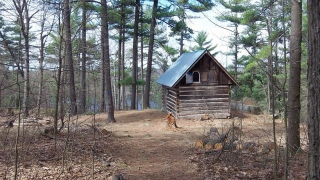
Cabin One


But even though the trail becomes more challenging you'll still have no issues. After the cabin the path starts to follow along the bay about 10 metres above the water level, rising higher in some points. Here is where you get you're first great view of the region. Make sure you take a few minutes at each of the courtesy benches to take in the amazing scenery.


As you get closer to the top the trail will turn from moderate to difficult. Be aware of what's ahead and take your time, you're far from the parking lot and no one wants to get hurt.

Moderate to Difficult


The last five minutes of the hike are the hardest. In a short five minutes you climb about 50 vertical metres to the summit. You know you're getting close when the trail turns from dirt to smooth rock.

But now you're finally here, you reached the summit of Rock Dunder. Take some time and enjoy the views and make sure you take lots of photos. On a nice clear day you can see as far as the 1,000 Islands Tower near the US border. Also, be sure to watch you're footing around the ledges, it's a long, steep way down.

After you've enjoyed your time at the top turn around a head back down the trail and back to the car knowing you reached the summit of Rock Dunder.


View from the Summit